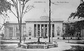
Columbus, Georgia
| City of Columbus | |
|---|---|
| — City — | |
 |
|
| Nickname(s): The Lowell of the South or The Fountain City | |
| Motto: What Progress Has Preserved | |
 |
|
| Coordinates: | |
| Country | United States |
| State | Georgia |
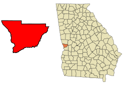
| County | Muscogee |
| Founded | 1828 |
| Named for | Christopher Columbus |
| Government | |
| - Mayor | Jim Wetherington |
| Area | |
| - Total | 220.8 sq mi (572 km2) |
| - Land | 216.1 sq mi (559.7 km2) |
| - Water | 4.7 sq mi (12.3 km2) |
| Population [1][2][3] | |
| - Total | 190,414 (121st) |
| - Density | 861.4/sq mi (332.6/km2) |
| - MSA | 292,795 |
| - CSA | 450,467 |
| Time zone | EST (UTC-5) |
| - Summer (DST) | EDT (UTC-4) |
| ZIP codes | 31820, 31829, 31900-09, 31914, 31917, 31993-94, 31997-99 |
| Area code(s) | 706, 762 |
| FIPS code | 13-19007[4] |
| GNIS feature ID | 0331158[5] |
| Airport | Columbus Metropolitan Airport- CSG |
| Website | City of Columbus |
Columbus is a city in and the county seat of Muscogee County, Georgia, United States,[6] with which it is consolidated. In 2009, its estimated population was 190,414.[1] It is the principal city of the Columbus, Georgia metropolitan area, which, in 2009, had an estimated population of 292,795. It joins with the Auburn, Alabama metropolitan area to form the Columbus, Georgia-Auburn, Alabama Combined Statistical Area, which, in 2009, had an estimated population of 450,467. It is the third largest city and fourth largest metropolitan area in the state, and also the 121st largest city in the United States.
Columbus lies 100 miles (160 km) south of Atlanta. Fort Benning, a major employer, is located south of the city in Chattahoochee County. The city is home to museums and other tourism sites. The area is served by the Columbus Metropolitan Airport. The current mayor is Jim Wetherington, who was elected in 2006. The city was ranked number 4 on the 100 Best U.S. Cities to live by Best Life Magazine.[7]
History
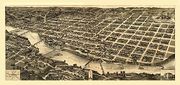
Founded in 1828 by an act of the Georgia Legislature, Columbus was situated at the beginning of the navigable portion of the Chattahoochee River and on the last stretch of the Federal Road before entering Alabama. The city was named for Christopher Columbus, its founders likely influenced by the writings of Washington Irving. The plan for the city was drawn up by Dr. Edwin L. DeGraffenried who placed the town on a bluff overlooking the river. Across the river, where Phenix City, Alabama is now located, Creek Indians lived until their removal in 1836.
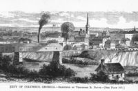
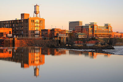
The river served as Columbus' connection to the world, particularly connecting the plantations in the region with the international cotton market via New Orleans and ultimately Liverpool, England. The city's commercial importance increased in the 1850s with the arrival of the railroad. In addition, textile mills began springing up along the river, bringing industry to an area reliant upon agriculture. By 1860, the city was one of the more important industrial centers of the South, earning it the nickname "the Lowell of the South," in deference to the industrial town in Massachusetts.
Civil War and Reconstruction
When the outbreak of war came in 1861, the industries of Columbus expanded their production and Columbus became one of the most important centers of industry in the Confederacy. During the war, Columbus ranked second to Richmond in the manufacture of supplies for the Confederate army.[8] In addition to textiles, the city had an ironworks and a sword factory as well as a shipyard for the Confederate Navy. Unaware of Lee's surrender to Grant and the assassination of Abraham Lincoln, Union and Confederates clashed in the Battle of Columbus, Georgia on Easter Sunday, April 16, 1865, when a Union detachment under General James H. Wilson attacked the city and burned many of the industrial buildings. The inventor of Coca-Cola, Dr. John Stith Pemberton, was wounded in this battle. The owner of America's last slave ship, Col. Charles Augustus Lafayette Lamar, was also killed here. A historic marker has been erected in Columbus marking the battle by Wilson's troops as the "Last Land Battle in the War Between the States."
Reconstruction began almost immediately and prosperity followed. Factories such as the Eagle and Phenix Mills were revived and the industrialization of the town led to rapid growth; the city outgrew its original plan. The Springer Opera House was built on 10th Street attracting such notables as Oscar Wilde. The Springer is now the official State Theater of Georgia.
By the time of the Spanish American War, the city saw much modernization including the addition of trolleys extending to outlying neighborhoods such as Rose Hill and Lakebottom and a new water works. Mayor Lucius Chappell also brought a training camp for soldiers to the area. This training camp named Camp Benning would grow into present day Fort Benning, named for General Henry L. Benning, a native of the city.
20th Century

With the expansion of the city, the need for a university saw the establishment of Columbus College, a two-year institution which would later grow into Columbus State University, now a comprehensive center of higher learning. The city would consolidate city and county governments in 1971 and become the first of its kind in Georgia (and one of only 16 in the U.S. at the time). As the city has turned from its initial industry of textiles, it has provided a home for other prominent industries including the headquarters for Aflac, Synovus, TSYS and Carmike Cinemas.
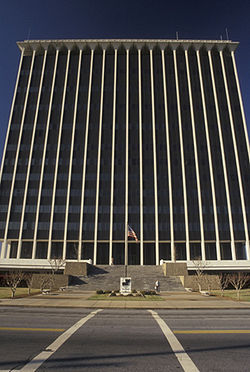
During the 1960s, 1970s and 1980s, urban blight, flight, and prostitution were serious problems in much of downtown Columbus and adjacent neighborhoods. Early efforts to halt the gradual deterioration of downtown began with the saving and lavish restoration of the Springer Opera House in 1965. With the revitalization of the Springer and its subsequent designation as the State Theatre of Georgia, a historic preservation movement was sparked and various historic districts were established in and around downtown. Large tracts of blighted areas were cleaned up and a modern Government Center was constructed in the city center. A significant period of urban renewal and revitalization followed in the mid to late 1990s. With these improvements, residents and businesses began moving back to these formerly blighted areas. Examples of these municipal projects including the construction of a softball complex which hosted the 1996 Olympic softball competition, construction of the Chattahoochee RiverWalk along the Chattahoochee River, construction of the National Civil War Naval Museum at Port Columbus, construction of the Coca-Cola Space Science Center, the expansion of the Columbus Museum, and road improvements to include a new downtown bridge crossing the Chattahoochee River to Phenix City. During the late 1990s and early 2000s, commercial activity expanded north of downtown along the I-185 corridor. During the next several years, the expansion will continue starting with the growth at Fort Benning. Over the next several years more than 15,000 troops moved to the Chattahoochee Valley.
21st century
In 2007, a documentary film entitled "The Last Ditch" [1] debuted on public television. It detailed the Civil War battle for Columbus, a struggle many historians consider to be the final "official" battle of the war. The film was nominated for five Southeast Regional Emmy awards, winning two.[9]
Geography

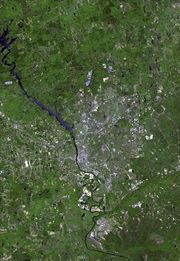
Columbus is one of Georgia's three Fall Line Cities, along with Augusta and Macon. The Fall Line is where the hilly lands of the Piedmont plateau meet the flat terrain of the coastal plain. As such, Columbus has a varied landscape of rolling hills on the north side and flat plains on the south. The fall line causes rivers in the area to decline rapidly towards sea level, making it an good location for textile mills in the past. The Chattahoochee River is the major river that runs through Columbus.
The city is located at (32.489608, -84.940422).[10]
According to the US Census Bureau, the city has a total area of 221.0 square miles (572.4 km2), of which, 216.3 square miles (560.1 km2) of it is land and 4.7 square miles (12.3 km2) of it (2.14%) is water.
Climate
Columbus has a humid subtropical climate. Daytime summer temperatures often reaches a high in the mid 90s, and low temperatures in the winter average in the upper 30s. Columbus is often considered a dividing line or "natural snowline" of the southeastern United States with areas north of the city receiving snowfall annually, with areas to the south typically not receiving snowfall every year or at all.
| Climate data for Columbus, Georgia | |||||||||||||
|---|---|---|---|---|---|---|---|---|---|---|---|---|---|
| Month | Jan | Feb | Mar | Apr | May | Jun | Jul | Aug | Sep | Oct | Nov | Dec | Year |
| Record high °F (°C) | 83 (28.3) |
83 (28.3) |
89 (31.7) |
93 (33.9) |
97 (36.1) |
104 (40) |
104 (40) |
104 (40) |
100 (37.8) |
94 (34.4) |
86 (30) |
82 (27.8) |
104 |
| Average high °F (°C) | 57 (13.9) |
62 (16.7) |
69 (20.6) |
77 (25) |
89 (31.7) |
90 (32.2) |
92 (33.3) |
91 (32.8) |
86 (30) |
77 (25) |
68 (20) |
59 (15) |
76.4 (24.68) |
| Average low °F (°C) | 37 (2.8) |
39 (3.9) |
46 (7.8) |
52 (11.1) |
61 (16.1) |
69 (20.6) |
72 (22.2) |
71 (21.7) |
66 (18.9) |
55 (12.8) |
46 (7.8) |
39 (3.9) |
54.4 (12.45) |
| Record low °F (°C) | -2 (-18.9) |
10 (-12.2) |
16 (-8.9) |
28 (-2.2) |
39 (3.9) |
44 (6.7) |
59 (15) |
57 (13.9) |
38 (3.3) |
24 (-4.4) |
10 (-12.2) |
4 (-15.6) |
-2 |
| Precipitation inches (mm) | 4.78 (121.4) |
4.48 (113.8) |
5.75 (146.1) |
3.84 (97.5) |
3.62 (91.9) |
3.51 (89.2) |
5.04 (128) |
3.78 (96) |
3.07 (78) |
2.33 (59.2) |
3.97 (100.8) |
4.40 (111.8) |
48.57 (1,233.7) |
| Source: Weather Channel [11] | |||||||||||||
Cityscape
Columbus is divided into five geographic areas, and they are as follows:[12]
- Downtown is the city's central business district, and home to many historic districts, homes, and churches such as the Columbus Historic Riverfront Industrial District, the Mott House, and the Church of the Holy Family. It is considered by some to be the area bounded on the north by Talbotton Road; on the South by 30th Avenue; on the West by Front Avenue the Chattahoochee River; and on the East by Brown Avenue.
- East Columbus is the largest of the five Columbus areas. It is home to Bull Creek Golf Course, the largest of seven golf courses in the city.[13] The area is roughly bounded by Macon Road to the North, Buena Vista Road to the South, Schatulga Road and Fort Benning to the East, and I-185 to the West.

- MidTown is a residential and commercial area. It is home to 2 major shopping areas: Peachtree Mall, an indoor shopping mall opened in 1975; The Landings, an outdoor strip mall that opened in 2005. MidTown is also home to the majority of bars and nightclubs in the Columbus area. It is bounded roughly by I-185 to the East, J. R. Allen Parkway to the North, River Road to the West and Wynnton Road to the South.
- North Columbus is a diverse suburban area of the city that is home to established neighborhoods and newly built subdivisions. It is home to very upscale areas such as Green Island Hills. It is also home to Columbus Park Crossing, a major outdoor strip mall. It is bounded roughly by Moore Road to the North, Manchester Expressway to the South, Moon Road to the East, and J. R. Allen Parkway to the West.
- South Columbus is situated just below MidTown, and just above the United States Army post Fort Benning. It is home to the National Infantry Museum, a museum that honors the history of infantry forces in the U.S. Army. In 2007, the area had an estimated population of 14,342.[14] The area mainly consists of Columbus' military living area.
Surrounding cities and towns
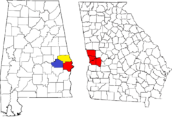
The Columbus Metropolitan Area includes four counties in Georgia, and two in Alabama. A 2008 Census estimate showed 287,653 in the metro area, with 442,953 in the combined statistical area. Below are the cities in the Columbus CSA:
|
|
|
|
|
|
Demographics
As of the census[4] of 2000, there were 186,291 people, 69,819 households, and 47,686 families residing in the city. The population density was 861.4 people per square mile (332.6/km2). There were 76,182 housing units at an average density of 352.3/sq mi (136.0/km2). The racial makeup of the city was 50.42% White, 43.74% African American, 1.54% Asian, 0.38% Native American, 0.14% Pacific Islander, and 1.90% from other races. Hispanic or Latino of any race were 4.49% of the population.
There were 69,819 households out of which 34.6% had children under the age of 18 living with them, 44.7% were married couples living together, 19.6% had a female householder with no husband present, and 31.7% were non-families. 26.7% of all households were made up of individuals and 9.4% had someone living alone who was 65 years of age or older. The average household size was 2.54 and the average family size was 3.08.
In the city the population was spread out with 26.8% under the age of 18, 11.9% from 18 to 24, 29.8% from 25 to 44, 19.7% from 45 to 64, and 11.7% who were 65 years of age or older. The median age was 33 years. For every 100 females there were 94.7 males. For every 100 females age 18 and over, there were 91.6 males.
The median income for a household in the city was $34,798, and the median income for a family was $41,244. Males had a median income of $30,238 versus $24,336 for females. The per capita income for the city was $18,262. About 12.8% of families and 15.7% of the population were below the poverty line, including 22.0% of those under age 18 and 12.1% of those age 65 or over.
Law and government
Elected Officials
Mayor
- Jim Wetherington
City Council
- Jerry Barnes (District 1)
- Glenn Davis (District 2)
- Julius Hunter, Jr. (District 3)
- Evelyn Turner-Pugh (District 4)
- Mike Baker (District 5)
- R. Gary Allen (District 6)
- Evelyn Woodson (District 7)
- C. E. McDaniel (District 8)
- Wayne Anthony (District 9)
- Berry "Skip" Henderson (District 10)
District Attorney
- Julia Slater [16]
Sheriff
- John Darr (2008)[17]
Tax Commissioner
- Lula Huff[18]
Clerk of Court
- Linda Pierce[19]
Crime
For 2008, Columbus had an overall crime rate of 8,533.7 per 100,000 residents;[20] this exceeds the national average of 4,479.3 crimes per 100,000 people by over 75%. By way of comparison, New York City's overall crime rate was 2,378 per 100,000 residents.[21]
The rate for violent crimes was 620.8 per 100,000, compared to the national average of 553.5 per 100,000; murders and robberies exceeded the national average, while rapes and aggravated assaults were below the national average. Property-crime rates, such as burglaries, larceny and motor vehicle thefts, significantly exceeded the national average (7,229.8 in Columbus, compared to the national average of 3,906.1).
Attractions and culture
Museums

- Founded in 1953, the Columbus Museum contains much artifacts on both American art and regional history, displayed in both its permanent collection as well as temporary exhibitions.
- Columbus is home to the National Civil War Naval Museum, a 40,000-square-foot (3,700 m2) facility that opened in 1962 and features two original American Civil War military vessels, uniforms, equipment and weapons used by the Union and Confederate navies.
- The Coca-Cola Space Science Center opened in 1996 for the purpose of public education in science, physics, and astronomy. It includes seven flight simulators and a planetarium.[22]
- The National Infantry Museum and Soldier Center opened in June 2009 and honors the service of Infantry forces in the United States Army. The museum includes displays related to the history of the Infantry from the founding of the nation to the present. It also has its own IMAX theatre.
Shopping
Columbus is served by one major indoor shopping mall, Peachtree Mall, which is anchored by major department stores Dillard's, Macy's, and J.C. Penney. The total retail floor area is 821,000 square feet (76,300 m2). Major strip malls include Columbus Park Crossing, which opened in 2004, and The Landings, which opened in 2005. Columbus is also served by The Shoppes at Bradley Park, a lifestyle center.
MidTown contains two of the city's early suburban shopping centers — the Village on 13th and St. Elmo — both recently renovated and each offering local shops, restaurants, and services.
Major venues
Below is the list of major venues in the city of Columbus:
- A. J. McClung Memorial Stadium, a football stadium. It was the site of the football games between the Georgia Bulldogs and the Auburn Tigers (the Deep South's Oldest Rivalry) from 1916 to 1958.
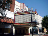
- The Bradley Theater, a performance theatre that opened in mid-1940 by Paramount Pictures.[23]
- Columbus Civic Center, a 10,000-seat multi-purpose arena that opened in 1996 and is home to the Columbus Lions in the SIFL, and the Columbus Cottonmouths in the SPHL. It is also the primary arena used for concert events in Columbus.
- Golden Park, a 5,000 seat baseball stadium, is the former home to the Columbus Catfish. It was also the site of the softball events of the 1996 Summer Olympics that were held in the city of Columbus.
- RiverCenter for the Performing Arts, a 2,000-seat modern performance theatre that first opened in 2002 and is operated by the Columbus not-for-profit organization RiverCenter Inc.
- Springer Opera House, a historic live performance theater located in Downtown that opened in early 1871. In 1992, it earned the nickname as the Official State Theatre of Georgia by former President Jimmy Carter.[24]
Walking trails
- The Chattahoochee RiverWalk is a 15 mile long bike trail that connects users from Downtown to South Columbus and the northern section of Fort Benning.
- The Columbus Fall Line Trace[25] is a fitness trail that runs from Downtown to the northeastern section of the city.[26]
Golf
Columbus is home to the following seven golf courses.[27]
- Bull Creek
- Country Club of Columbus
- Follow Me
- Godwin Creek
- Green Island Country Club
- Maple Ridge Golf Club
- Oxbow Creek Golf Course
Libraries
Columbus is served by four branches of the Chattahoochee Valley Libraries:
- Columbus Public Library
- Mildred L Terry Public Library
- North Columbus Public Library
- South Columbus Public Library
Parks
Historic Districts

Columbus is home to 7 historic districts, all listed in the NRHP. They are as follows:
- Columbus Historic District
- Columbus Historic Riverfront Industrial District
- Dinglewood Historic District
- Peacock Woods-Dimon Circle Historic District
- Weracoba-St. Elmo Historic District
- Wynn's Hill-Overlook-Oak Circle Historic District
- Wynnton Village Historic District
Media and communications
Newspapers
- The Ledger-Enquirer, the only daily newspaper in Columbus.
- The Columbus Times, a weekly publication featuring African-American perspectives of current events.
- The Bayonet, a weekly publication of news and events in Fort Benning and south Columbus.
- Playgrounds Magazine, a monthly entertainment and arts magazine.
- The Saber, the Columbus State University campus newspaper.
- Tid Bits, a weekly publication featuring news throughout the southeast.
- To Do, a weekly publication featuring current events.
Radio
AM stations
- WDAK 540 (News, Talk)
- WBIL 580 (Gospel)
- WZMG 910 (Urban adult contemporary)
- WAUD 1230 (Sports, Music,
- WSHE 1270 (Southern Gospel)
- WOKS 1340 (Rhythmic oldies)
- WRCG 1420 (Oldies)
- WHAL 1460 (Sports)
- WTLM 1520 (Oldies)
- WIOL 1580 (Sports)
FM stations
- WJSP 88.1 (Public radio)
- WBOJ 88.5 (Contemporary Christian)
- WELL 88.7 (Contemporary Christian)
- WYFK 89.5 (Religious)
- WFRC 90.5 (Christian)
- WEGL 91.1 (Variety)
- WTJB 91.7 (Classical)
- WKZJ 92.7 (Urban adult contemporary)
- WVFJ 93.3 (Contemporary Christian)
- WQSI 93.9 (Classic country)
- WRLD 95.3 (Classic hits)
- WIOL 95.7 (Sports)
- WTGZ 95.9 (Modern rock)
- WBUE 96.1 (Contemporary Christian)
- WMXA 96.7 (Adult contemporary)
- WURY 97.1 (Religious)
- WKKR 97.7 (Country)
- WBFA 98.3 (Urban contemporary)
- WKCN 99.3 (Country)
- WQNR 99.9 (Variety hits)
- WGSY 100.1 (Adult contemporary)
- WEAM 100.7 (Gospel)
- WAGH 101.3 (Urban adult contemporary)
- WVRK 102.9 (Album-oriented rock)
- WLTC 103.7 (Light rock)
- WAUF 104.5 (Contemporary Christian)
- WFXE 104.9 (Urban contemporary)
- WSTH 106.1 (Country)
- WRCG 106.9 (Oldies)
- WCGQ 107.3 (Contemporary hits)
Television
- WRBL 3, Media General, Inc (CBS)
- 3.2 WRBL-DT2 (RTN)
- 3.3 WRBL-DT3 (AccuWeather)
- W06BH 6, (Religious)
- WTVM 9, Raycom Media (ABC)
- 9.2 WTVM-DT2 (AccuWeather)
- WWCG 11, White Springs Media (WSTV)
- WYBU 16, Christian Television Network (CTN)
- WACS 25, Georgia Public Telecommunications Commission (GPB, PBS)
- 25.2 WACS-DT2 (GPB Kids)
- 25.3 WACS-DT3 (GPB Knowledge)
- WJSP 28, Georgia Public Telecommunications Commission (GPB, PBS)
- 28.2 WJSP-DT2 (GPB Kids)
- 28.3 WJSP-DT3 (GPB Knowledge)
- WLTZ 38, SagamoreHill Broadcasting (NBC)
- 38.2 WLTZ-DT2 (The CW)
- WGIQ 43, Alabama Public Television (PBS, APT)
- WXTX 54, Southeastern Media Holdings (Fox, myNetworkTV)
- 54.2 WXTX-DT2 (This TV)
Movie theaters
There are 5 movie theaters located in the Columbus area. They are as follows:
Education
Primary and secondary education
The Muscogee County School District holds grades pre-school to grade twelve, that consists of thirty-five elementary schools, twelve middle schools, and eight high schools.[28][29] The district has 2,068 full-time teachers and over 32,944 students.[30]
Higher education
Public
- Columbus State University
- Columbus Technical College
- Georgia Military College - main campus in nearby Milledgeville, Georgia
- Miller-Motte Technical College
- Troy University - main campus in Troy, Alabama
Private
- Christian Life School of Theology
- Rivertown School of Beauty
- Southeastern Beauty School
- University of Phoenix - main campus in Phoenix, Arizona
Hospitals
- Aflac Cancer Center and Blood Disorders Service
- Columbus Regional Hospital
- Columbus Specialty Hospital
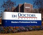
- Doctors Hospital
- Hughston Orthopedic Hospital
- Martin Army Community Hospital
- St. Francis Hospital
- West Central Georgia Regional Hospital
Transportation
Air
Public airports
- The Columbus Metropolitan Airport (IATA: CSG, ICAO: KCSG, FAA LID: CSG) is the metro area's primary airport and the fourth busiest airport in Georgia. It is located just off of I-185 exit 8. It is served by Atlantic Southeast Airlines and American Eagle, both of whom offer many daily flights to Atlanta and Dallas/Fort Worth.[31]
Private airports
The following private general aviation airports operate in the metropolitan area:
- Harris County Airport (IATA: PIM, ICAO: KPIM, FAA LID: PIM), located in Pine Mountain, Georgia.
- Jones Light Aviation Airport, located in Smiths Station, Alabama
- Marion County Airport, located in Buena Vista, Georgia.
Military airports
- Lawson Army Airfield (IATA: LSF, ICAO: KLSF, FAA LID: LSF), located on Fort Benning.
Freeways
Interstate Highways
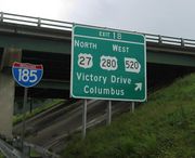
.svg.png) Interstate 185
Interstate 185
U.S. Routes
 U.S. Route 27
 U.S. Route 80
 U.S. Route 280
 U.S. Route 431
Georgia State Routes
 S.R. 1
 S.R. 22
 S.R. 219
 S.R. 411
 S.R. 520
 S.R. 540
Public transit
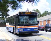
METRA Transit System operates within Columbus, which connects riders to places within the City. METRA was first incorporated in 1924 to furnish bus service in the Columbus metropolitan area.[32] METRA can transport an adult anywhere in the city for a fee of $1.30.[33]
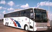
Greyhound Lines provides intercity bus service with a station on Veterans Parkway in Downtown.[34]
Religion
Christianity
Columbus contains approximately 200 Christian churches, with the Southern Baptist Convention being the largest denomination by number of churches.[35]
Judaism
Columbus is home to one Synagogue (Temple Israel).
Islam
Columbus is home to three Mosques (Masjid Al Jannah, Masjid An-Nur and Masjid Abdullah Bin Masud.)
Jehovah's Witnesses
Columbus is also home to two Kingdom Halls for Jehovah's Witnesses.[36]
Sports
| Club | Sport | League | Venue | Logo |
| Columbus Cottonmouths | Ice hockey | Southern Professional Hockey League | Columbus Civic Center | |
| Columbus Lions | Indoor football | Southern Indoor Football League | Columbus Civic Center | |
| Columbus Life | Basketball | American Basketball Association | Columbus State University | |
| CSU Cougars | Baseball, Basketball, Cross Country/Track,Golf, Tennis | NCAA Division II (Peach Belt Conference) | Columbus State University | |
| Columbus Wood Bats | Baseball | Great South League | Charles F. Ragsdale Field |
Sister cities
Columbus has four official sister cities:[37]
Notable Columbusites
The following people are closely associated with the city of Columbus, or one of its surrounding communities, and have garnered a level of national or international recognition. For a more comprehensive list of notable Columbus natives and residents, see People from Columbus, Georgia.
|
|
See also
- Downtown Columbus
- MidTown Columbus
- List of neighborhoods in Columbus, Georgia
- List of mayors of Columbus, Georgia
- List of schools in Muscogee County, Georgia
- Metro Columbus
References
- ↑ 1.0 1.1 Columbus QuickFacts, U.S. Census Bureau (July 1, 2009)
- ↑ "Table 1. Annual Estimates of the Population of Metropolitan and Micropolitan Statistical Areas: April 1, 2000 to July 1, 2009 (CBSA-EST2009-01)" (CSV). 2009 Population Estimates. United States Census Bureau, Population Division. 2010-03-23. http://www.census.gov/popest/metro/tables/2009/CBSA-EST2009-01.csv. Retrieved 2010-03-24.
- ↑ "Table 2. Annual Estimates of the Population of Combined Statistical Areas: April 1, 2000 to July 1, 2009 (CBSA-EST2009-02)" (CSV). 2009 Population Estimates. United States Census Bureau, Population Division. 2010-03-23. http://www.census.gov/popest/metro/tables/2009/CBSA-EST2009-02.csv. Retrieved 2010-03-24.
- ↑ 4.0 4.1 "American FactFinder". United States Census Bureau. http://factfinder.census.gov. Retrieved 2008-01-31.
- ↑ "US Board on Geographic Names". United States Geological Survey. 2007-10-25. http://geonames.usgs.gov. Retrieved 2008-01-31.
- ↑ "Find a County". National Association of Counties. http://www.naco.org/Template.cfm?Section=Find_a_County&Template=/cffiles/counties/usamap.cfm. Retrieved 2008-01-31.
- ↑ 100-Best Places to Live Retrieved 2009-08-06
- ↑ Encyclopaedia Britannica. vol. VI. New York. 1911. p. 746.
- ↑ 2008 Southeast Regional Emmy Awards, natassoutheast.tv; retrieved July 1, 2008
- ↑ "US Gazetteer files: 2000 and 1990". United States Census Bureau. 2005-05-03. http://www.census.gov/geo/www/gazetteer/gazette.html. Retrieved 2008-01-31.
- ↑ Average weather for Columbus Weather Channel Retrieved 2009-04-27
- ↑ All neighborhood info and names taken from Google Maps.
- ↑ Columbus golf info, Retrieved September 2009
- ↑ South Columbus on City Data, Retrieved September 2009
- ↑ Columbus City Council. Retrieved 2010-07-29.
- ↑ Office of the District Attorney for Chattahoochee Judicial Circuit. Retrieved 2010-07-29.
- ↑ Muscogee County Sheriff's Office. Retrieved 2010-07-29.
- ↑ Columbus Consolidated Government City Phone Directory. Retrieved 2010-07-29.
- ↑ Office of the Clerk of Superior, State & Juvenile Courts of Muscogee County. Retrieved 2010-07-29.
- ↑ Columbus, Georgia profile (city-data.com). Retrieved 2010-07-29.
- ↑ New York, New York profile (city-data.com). Retrieved 2010-07-29.
- ↑ http://www.ccssc.org/ Description
- ↑ Bradley Theatre info page, retrieved August 2009
- ↑ Georgia Secretary of State - State Theatre, sos.state.ga.us; retrieved February 2007 (from Springer Opera House).
- ↑ Columbus "Rails to Trails" Project gets its new name at WTVM.com. Retrieved 2010-07-29.
- ↑ Trail map. Retrieved 2010-07-29.
- ↑ [Columbus, Georgia Golf Courses]. Retrieved 2010-07-29.
- ↑ List of schools in Columbus, Retrieved Sept. 2009.
- ↑ Georgia Board of Education, Retrieved June 24, 2010.
- ↑ School Stats, Retrieved June 24, 2010.
- ↑ Official website
- ↑ About METRA. Retrieved 2010-07-07.
- ↑ METRA fares. Retrieved 2010-07-07.
- ↑ Columbus Greyhound station info, Retrieved Sept. 2009
- ↑ Churches in Columbus Retrieved August 29, 2009
- ↑ Kingdom Halls in Columbus, Georgia. Retrieved 2010-07-07.
- ↑ [http://www.columbusga.org/mayor/circle.htm#sis Sister City Relationships]. Retrieved 2010-07-07.
- ↑ President Mirabeau B. Lamar, tsl.state.tx.us; retrieved March 2008
External links
- Official Homepage
- Columbus Georgia Consolidated Government
- Columbus Georgia's Social Network, Blog, Forum, Web Portal, and More.
- Listen to Columbus Police and Fire department radio communications
- Columbus (entry in the New Georgia Encyclopedia)
- Columbus travel information from Wikitravel
- The Official Site for Visitor Information for Columbus, GA
- Columbus Enquirer Archive Digital Library of Georgia
- Columbus, Geo., from its selection as a "trading town" in 1827, to its partial destruction by Wilson's raid, in 1865, by John H. Martin. Publisher: Columbus, Ga., T. Gilbert, 1874-75. (searchable facsimile at the University of Georgia Libraries; DjVu & layered PDF format)
- Web site for the documentary film on the Civil War battle for Columbus
 |
Opelika, Alabama | Atlanta | Griffin | |
| Phenix City, Alabama | Macon | |||
| Union Springs, Alabama | Albany | Americus |
|
|||||||||||||||||
|
|||||||||||||||||||
|
|||||||||||||||||
|
|||||||||||||||||
|
|||||||||||||||||
|
|||||||